Award for aerial mapping technology measuring tree canopy
Published on 29 October 2021
The South Australian Award for Environment and Sustainability went to Aerometrex and the City of Unley for collaborative work in data collection and interpretation, which seeks to measure tree coverage across the urban landscape and address climate change issues, reducing urban heat impacts and achieving better maintenance of green canopy.
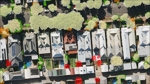
Aerometrex and the City of Unley received the award for the ‘Very High-Resolution Light Detection and Ranging (LiDAR) Derived Tree Canopy Change Detection’ project, to help explore policy development and financial incentives to protect and improve tree canopy cover on private land. The company and Council successfully collaborated to create property-specific spatial data on changes to tree canopy. A full urban forest assessment across the local government area was captured with LiDAR in 2021 to provide updated mapping of tree canopy coverage, which was compared with previous benchmarks acquired by aerial flyovers during 2018.
The work supports efforts to retain and increase urban canopy cover on both public and private land as Unley adapts to a warming climate. Today, the City of Unley has a greatly enriched understanding of the tree canopy area, coverage, and changes over time on which to base policy decisions. The award judges noted the benefits of Council having more accurate data to be able to communicate more effectively with their community on tree management.
The City of Unley’s Mayor Michael Hewitson said the importance and relevance of the new technology and methods of mapping cannot be underestimated.
‘I was thrilled when we first received data about the impact of established trees on the ambient temperature of our streets, which showed differences of up to 10 degrees Celsius between streets that had shade trees and those that didn’t. However, this latest refinement in mapping methods of has given us information down to individual homes. This means we can tell our residents what percentage of green cover they have on their individual properties. It’s the evidence we need to persuade homeowners to plant more trees on private land and to incentivise developers who are subdividing larger blocks, which is often where we are losing significant trees. The LiDAR technology is a real game-changer for us as a Council.’
The geospatial science awards were presented by the Spatial Industries Business Association and Geospatial Information and Technology Association, (SIBA-GITA) the industry’s peak body, whose vision is to see mapping information underpin digital transformation in Australasia. Its members include spatial services businesses, educational institutions and government agencies, and organisations who use spatial information in public and private sectors.
The awards were also supported by the Surveying and Spatial Sciences Institute (SSSI), a globally recognised forum for the spatial community which leads, advocates and is supported by the four pillars of the spatial industry – academia, government, research, and the private sector. Both organisations say the awards celebrate emerging technologies and are an opportunity to grow the capabilities of members so the industry can contribute to the Asia-Pacific region’s prosperity and sustainability and build a more innovative, entrepreneurial Australia.